-
About Upazila
Introduce to upazila
History & Traditions
Geography & Economics
Others
-
Upazila Parishad
About Parishad
Resolution of Upazila Monthly General Meeting
Resolution of Upazila Committee
-
আইন শৃঙ্খলা কমিটি
-
যোগাযোগ ও ভৌত অবকাঠামো উন্নয়ন কমিটি
-
কৃষি ও সেচ কমিটি
-
মাধ্যমিক ও মাদ্রাসা শিক্ষা কমিটি
-
প্রাথমিক শিক্ষা কমিটি
-
স্বাস্থ্য ও পরিবার কল্যাণ কমিটি
-
যুব ও ক্রীড়া উন্নয়ন কমিটি
-
নারী ও শিশু উন্নয়ন কমিটি
-
সমাজ কল্যাণ কমিটি
-
মুক্তিযোদ্ধা কমিটি
-
মৎস্য ও প্রাণিসম্পদ কমিটি
-
পল্লী উন্নয়ন ও সমবায় কমিটি
-
সংস্কৃতি কমিটি
-
বন ও পরিবেশ কমিটি
-
বাজার মূল্য পর্যবেক্ষণ, মনিটরিং এবং নিয়ন্ত্রণ কমিটি
-
অর্থ, বাজেট, পরিকল্পনা এবং স্থানীয় সম্পদ আহরণ কমিটি
-
জনস্বাস্থ্য, স্যানিটেশন এবং বিশুদ্ধ পানীয় জল সরবরাহ কমিটি
Five Year Plan
Designated Officer
Citizen Charter
-
আইন শৃঙ্খলা কমিটি
-
Upazila Administration
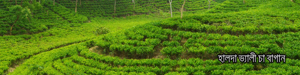
Upazila Nirbahi Officer
About Organogram
Schedule & Meeting
Services & Others
- Municipality
-
Govt. Offices
Law and order offices
Educational & Cultural Related
Agriculture, Fisheries, Livestock and Food Related
Health & environment related
Engineering and ICT Related
Human Resources Development Related
Land Affairs & Revenue Related
-
Different Institutions
Educational Institution
- National e-service
- Gallery
- Fatikchhari flood-2024
- Smart Fatikchari
-
About Upazila
Introduce to upazila
History & Traditions
Geography & Economics
Others
-
Upazila Parishad
About Parishad
Resolution of Upazila Monthly General Meeting
Resolution of Upazila Committee
- আইন শৃঙ্খলা কমিটি
- যোগাযোগ ও ভৌত অবকাঠামো উন্নয়ন কমিটি
- কৃষি ও সেচ কমিটি
- মাধ্যমিক ও মাদ্রাসা শিক্ষা কমিটি
- প্রাথমিক শিক্ষা কমিটি
- স্বাস্থ্য ও পরিবার কল্যাণ কমিটি
- যুব ও ক্রীড়া উন্নয়ন কমিটি
- নারী ও শিশু উন্নয়ন কমিটি
- সমাজ কল্যাণ কমিটি
- মুক্তিযোদ্ধা কমিটি
- মৎস্য ও প্রাণিসম্পদ কমিটি
- পল্লী উন্নয়ন ও সমবায় কমিটি
- সংস্কৃতি কমিটি
- বন ও পরিবেশ কমিটি
- বাজার মূল্য পর্যবেক্ষণ, মনিটরিং এবং নিয়ন্ত্রণ কমিটি
- অর্থ, বাজেট, পরিকল্পনা এবং স্থানীয় সম্পদ আহরণ কমিটি
- জনস্বাস্থ্য, স্যানিটেশন এবং বিশুদ্ধ পানীয় জল সরবরাহ কমিটি
Annual Economic Report
Annual Development Plan
Five Year Plan
Designated Officer
Citizen Charter
-
Upazila Administration
Upazila Nirbahi Officer
About Organogram
Schedule & Meeting
Services & Others
-
Municipality
Fatikchari Municipalty
Nazirhat Municipality
-
Govt. Offices
Law and order offices
Educational & Cultural Related
Agriculture, Fisheries, Livestock and Food Related
Health & environment related
Engineering and ICT Related
Human Resources Development Related
Land Affairs & Revenue Related
-
Different Institutions
Educational Institution
- National e-service
-
Gallery
Photo Gallery
Video Gallery
-
Fatikchhari flood-2024
List by union
-
Smart Fatikchari
Submit Idea/Project
Instructions
Form (For Upazila Level)
At one point Fatikchhari Fatikchari is an area of 773 square kilometer in Chittagong district, and it is the largest upazila of the district.
|
1. |
Fatikchari Nomination: |
|
Fatikchhari has been named after the name of Fatikchhari rhyme (transparent water rhyme) in Harvalalshari of this upazila. In 1918, the first establishment of the Fatikchari thana was established. In 1983, Fatikchhari thana was upgraded to the upazila. |
|
2. |
Size and Location
|
|
773.55 sq km It is located 22635 north latitude northwest of 22nd and 91˙38 to 91.157 east longitude. |
|
3. |
Borders
|
|
Manikchari, Lakshchhari and Raozan on the east, Mirsharai and Sitakunda upazilas on the west, Ramgarh and Tripura in the north, Hathazari upazila on the south.
|
|
4. |
Population |
|
(A) Males: 2,59,730 people Total number of voters = 3,77,893 (B) Female: 2,66273 people (Source: Census 2011) Total = 5,26,203 people |
|
5. |
The rate of education
|
|
51 40%
|
|
6. |
Thanas |
|
02 (Fatikchari and Bhujpur thanas).
|
|
7. |
Union |
|
18 |
|
8. |
Union Information & Service Center |
|
18 |
|
9. |
Municipality |
|
2 (Fatikchari municipality and newly formed municipality of Nazirhat).
|
|
10. |
Moujah |
|
97 |
|
11. |
Village |
|
206
|
|
12. |
Distance from district sadar to upazila
|
|
45 kilometers |
|
13. |
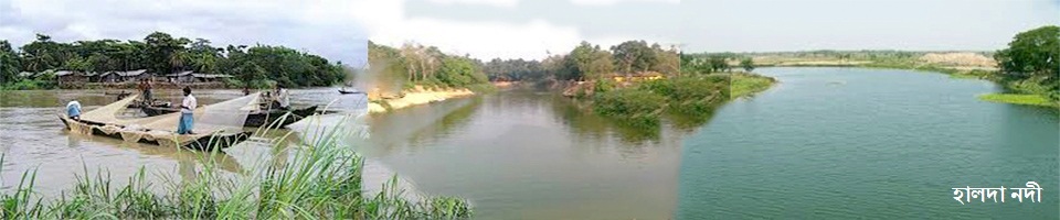
River
|
|
02. (Halda and Feni rivers)
|
|
14. |
Canal
|
|
20.
|
|
15. |
Hats and bazars
|
|
56th Famous Bazar: Bibirhat, Nazirhat, Heyanko Bazar, Narayanhat, Kalimunshi Bazar, Kazirhat, Md. Kakirhat and Azadi Bazar.
|
|
16. |
UP-Kam-Community Center: |
|
18 |
|
17. |
Public library
|
|
1 |
|
18. |
Auditorium
|
|
1 |
|
19. |
Children Academy |
|
1 |
|
20. |
Children's Park
|
|
1 |
|
21. |
Dak Bungalow (Revenue House) |
|
1 |
|
22. |
Power Supply Center |
|
2
|
|
23. |
Bank |
|
28 (Government-13, non-government -15)
|
|
24. |
Historical Places |
|
01 (Company Tila, Harmalchari).
|
|
25. |
Holy place |
|
01 (Maijbhandar Sharif Mazar) |
|
26. |
Historical Buddhism |
|
01, Korarpar fort, Jahanpur |
|
27. |
Stadium |
|
1 |
|
28. |
College |
|
05
|
|
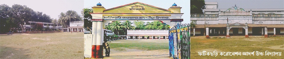
29. |
Secondary School: |
|
57
|
|
30. |
Primary School |
|
225 (two hundred and twenty five).
|
|
31. |
KG School |
|
58
|
|
32. |
Madrasa |
|
34 (thirty-four) There are no government, private male madrasa 30, female madrasa 04.
|
|
33. |
agricultural land |
|
90,500.80 acres
|
|
34. |
The amount of cultivable land |
|
61,626.50 acres
|
|
(A) One crop |
|
37445.20 acres
|
|
|
(B) Two crops |
|
2180. 25 acres
|
|
|
(C) Three crops |
|
2939.30 acres
|
|
|
35. |
Main crops |
|
Paddy, potato, chilli, mustard, fennel pulses, curry leaves, winter and summer vegetables |
|
36. |
Main crop production |
|
Paddy Total - 139,000 Metricton (16-17 FY), Potato Total - 5600 Metricton
|
|
37. |
Total animal resources:
|
|
1,08,513 Total Animal Medical Centers -01 Total Poultry Farm- 270 Total Dairy Farm - 60 |
|
38. |
Union Land Office: |
|
06 |
|
39. |
Sub-Registered Office: |
|
03 (Fatikchhari, Kazirhat and Nanupur) |
|
40. |
Agriculture Khas Land: |
|
1545.02 acres. |
|
41. |
(A) Eligible Agricultural Khas Land: |
|
90.04 acres. |
|
(B) Inadequate Agricultural Khas Land: |
|
1454.98 acres. |
|
|
(C) Number of landless families given to the settlement |
|
253 people (from 2008-2009 to 2012-2013)
|
|
|
42. |
Non-agricultural land: |
|
10464.59 acres |
|
43. |
(A) Valuable non-agricultural land for settlement: |
|
3321.25 acres. |
|
(B) Inadequate non-agricultural land: |
|
7143.34 acres. |
|
|
(C) Non-agricultural land: |
|
172.85 acres. |
|
|
44. |
handed over property A) '' A '' is the amount of land which is landed |
|
155.17 acres |
|
45. |
Waqf Estate: |
|
11 |
|
46. |
Total roads: |
|
1948.97 kilometers (pucca -2.0.15 km, raw -1486.57 km, semi-well-172.25 kilometers) |
|
47. |
Total number of bridges: |
|
123 |
|
48. |
Total culvert: |
|
745 |
|
49. |
Food warehouse. |
|
01 (03 units) |
|
50. |
Tea Board Institute. |
|
01 |
|
51. |
Forests. |
|
73,634.26 acres |
|
52. |
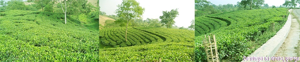
Tea gardens: |
|
17 |
|
53. |
Rubber gardens |
|
03 |
|
54. |
Rubber Technical Training Center: |
|
01. |
|
55. |
Army Camps |
|
(2) (Bainasola Army Camp, Kanchannagar, Khiram Army) Camp, Magakata, Nanpurur) |
|
56. |
BGB camps: |
|
04 (gardening, semi-standard, ponua and haenako) |
|
57. |
Range Office: |
|
05 |
|
58. |
Bit Office: |
|
14. |
|
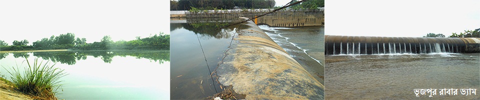
59. |
Rubber Dam |
|
2 (Haramalchari and Bhujpur rubber dam) |
|
60. |
Slotted Calls: |
|
93 |
|
61. |
Balumahal: |
|
43 |
|
62. |
Brick field; |
|
49; Total land area = 155.17 acres. |
|
63. |
Palmwell Garden: .
|
|
01 |
|
64. |
El LP (Low Elevator Pump):
|
|
1126 |
|
65. |
Artigen (source): |
|
1100 |
|
66. |
Deep tube well
|
|
03 |
|
67. |
Shallow tube well: |
|
217 |
|
68. |
SUNNIS GATE: |
|
06. |
|
69. |
Cross Dam: |
|
317 |
|
70. |
Fertilizer Warehouse: |
|
04. |
|
71. |
Union seeding: |
|
16. |
|
72. |
Nursery Center: |
|
01. |
|
73. |
Reserve Forrest: |
|
62,225.29 acres. |
|
74. |
Social forestry: |
|
9410.70 acres. |
|
75. |
Number of Beneficiaries: |
|
3,907 |
|
76. |
Ardesh village: 04 |
|
(1. Badurkhali Adarsh village, 2. Azimpur ideal village, 3. West Bhujpur ideal village, 4. Uttara Rangamatiya ideal village). |
|
77. |
Ashrayan Project: |
|
04 |
|
78. |
Lelang AshrayanProject:
|
|
140 beneficiaries.
|
|
Suebil Ashrayan Project: |
|
130 people benefitted |
|
|
North Pyondang Ashrun Project- |
|
01: Number of beneficiaries of 80 people |
|
|
North Pyondang Ashrun Project- |
|
02: Number of Beneficiaries 140 |
|
|
79. |
Barmasia Ashrayan Project:. |
|
The number of beneficiaries is 135 people |
|
80. |
Total Sanitation:
|
|
71718 (Pucca -71599 and Raw-119) |
|
81. |
Total mosques / temples / churches / pagodas |
|
972. Total mosques - 852, Total temples - 83, Churches - 01, Pagoda - 36. |
|
82. |
Central Cooperative Societies: |
|
2 |
|
(A) Agricultural Co-operative Society: |
|
23 |
|
|
(B) Women's Association: |
|
33 |
|
|
(C) Non-cooperative cooperative societies:. |
|
117 |
|
|
(D) Other co-operative societies: |
|
29 |
|
|
83. |
Mother's center: |
|
30 |
|
84. |
Registered Club: |
|
103 |
|
85. |
Registered orphanage: |
|
66 (Social Services - 37, Others - 29) |
|
86. |
Ganmilanatan Center: |
|
09 |
|
Show fish fisheries: |
|
03. |
|
|
Government Water Mahal |
|
08 |
|
|
87. |
Hospital:
|
|
02 (Government), 50 beds 01, Najirhat, Fatikchari 20 beds 01, Bibirhat, Fatikchhari. |
|
(A) Union Health Center: |
|
10. |
|
|
(B) Family Planning Center:. |
|
07 |
|
|
(C) Community clinic: |
|
51 |


Planning and Implementation: Cabinet Division, A2I, BCC, DoICT and BASIS
Technical Assistance:
![]()
Developed By:
